kirra-docs
Contour Surface
Draws contour lines across a surface at a regular elevation interval. Use them to read a pickup at a glance, to check a design floor, or to export bench and toe strings to CAD.
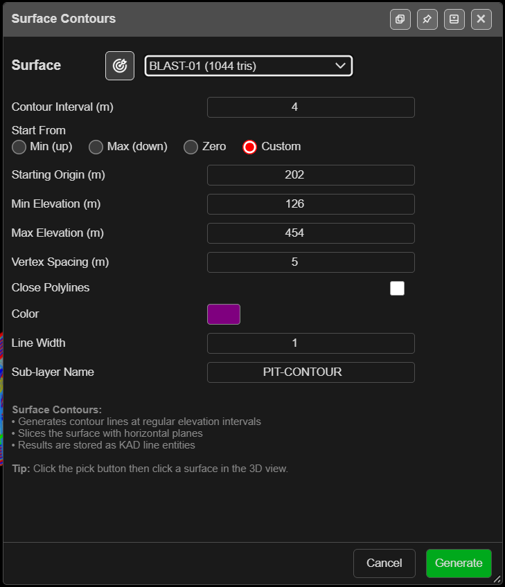
Contour a surface
- Click Contour Surface on the Surface toolbar. The Surface Contours dialog opens.
- Choose the Surface, or click the target button and click the surface in the 3D view. The picked surface flashes green.
- Set Contour Interval (m) and where the levels start (below).
- Click Generate. The contours are added as KAD lines and Kirra reports how many were made.
With no surfaces loaded, Kirra says “No surfaces loaded. Import a surface (DTM, STR, OBJ) first.” The list includes hidden surfaces.
The fields
| Field | Default | What it does |
|---|---|---|
| Contour Interval (m) | 5 | Vertical distance between contours |
| Start From | Min (up) | Where the levels are counted from: Min (up), Max (down), Zero or Custom |
| Starting Origin (m) | The surface’s lowest point | The level the interval is counted from. Editable with Custom only |
| Min Elevation (m) | Lowest point, rounded down | No contours below this |
| Max Elevation (m) | Highest point, rounded up | No contours above this |
| Vertex Spacing (m) | 0 | Simplifies the lines: vertices closer than this are dropped. 0 keeps every vertex |
| Close Polylines | Off | Closes each contour into a polygon |
| Color | Yellow | Colour of the contours |
| Line Width | 2 | Line width (1–10) |
| Sub-layer Name | Contours | The sub-layer the contours are filed in |
Levels are the Starting Origin (m) plus whole multiples of the interval, between the min and max. With Zero and a 2 m interval, contours fall on even RLs — 616, 618, 620 and so on.
The dialog remembers your settings in this browser. Choosing a different surface refills the min and max from that surface.
Tip: To contour your bench RLs exactly, choose Custom, type one bench RL as the Starting Origin (m) and use the bench height as the interval.
What you get
KAD lines — or polygons, with Close Polylines — in the Analysis layer under the
Sub-layer Name, or in your active layer if you have chosen one. Each is named after the
surface and its RL, for example Pit_Contour_RL640_001_a4zz, so sorting by name groups each
level together. The surface itself is not changed. The whole set is one undo step.
The result message lists the count, the elevation range, the interval and the time taken.
Troubleshooting
| Symptom | Cause | Fix |
|---|---|---|
| “Contour interval must be greater than 0.” | Interval is 0 or blank | Enter an interval |
| “Too many contour levels (…)” | Over 5,000 levels in the range | Raise the interval or narrow the range |
| “No contour lines generated.” | The range misses the surface | Reselect the surface to refill Min and Max |
| Min and max belong to the last surface | The dialog remembers them | Choose the surface again to refill them |
| A Large Surface warning | The surface is over the 3D triangle limit | Generate anyway, Adjust Settings, or Cancel |
Other ways to use it
| Method | Result |
|---|---|
| Start From → Custom | Contours on your own datum, such as bench RLs |
| Sub-layer Name | A separate folder per run — for example PitShell |
| Close Polylines | Closed rings, ready for clipping or extruding |
| Vertex Spacing (m) above 0 | Lighter lines for export |
Related
- Solid Horizon Slice — cut a solid at the same levels
- Surface Gradients
- Layer Organisation
- DXF Export
- Surfaces Toolbar